Keep the original record in view. This growing library connects study tools with historical-map records, books and research trails, including resources discovered through Dante Fortson’s Black History In The Bible.
Read Scripture · Continue the study
All 39 Old Testament books.
Begin reading the Terrence L Pounds Study Edition. Commentary and study materials are continually being expanded and revised.
Map names, dates and historical descriptions begin an inquiry. Open the holding library’s record, compare the exact wording, and keep your conclusions alongside the evidence.
External sources remain with their original hosts. Map records link to the original images or archive viewers; this site does not claim ownership of those collections.
From the book’s historical-map section
See the map. Then examine the detail.
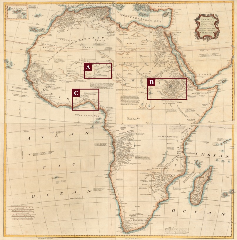
These historical reproductions and marked study details are already included in Remembering YAH. Tap a map to open the full available image, then zoom in with your browser. Dates and edition questions remain attached to their source records below.
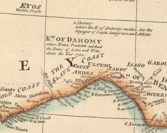
Sanuto atlas tradition, 1588. Visible sheet: AFRICAE TABVLA XII. Reproduction via BHITB; study box from Remembering YAH.Box A enlarged: IVDEORVM TERRA. Keep the visible label separate from conclusions about modern populations.D’Anville / Bolton / Bowen map reproduction via BHITB. Yale catalog lead below. BHITB’s 1774 exhibit and 1766 image filename require edition comparison.Detail A: Lamlem annotation. Read its attribution and past-tense wording in the map’s own context.Detail B: Falasjam. A separate label from the Lamlem annotation.Detail C: coastal wording and location. Compare these place-names with the map’s full geography.
A credited research trail
Go deeper, one source at a time.
Start with the maps reproduced in Remembering YAH, browse the historical books, then follow the external indexes. Dante Fortson and Black History In The Bible are credited for the research leads they assembled. These entries distinguish source records, interpretations and items still awaiting passage-level verification.
This is an expanding catalog of recovered sources, not a complete reproduction of Fortson’s websites. His full articles, videos and broader catalog remain available through the credited links.
Map1710
Moll’s map of Africa
Herman Moll · Princeton University
Explore the full historical map associated with the book’s inquiry into West African place-names. Examine the coast and the labels in their geographical setting.
Source notes
Discovery trail: Dante Fortson’s BHITB map exhibit. A place-name resemblance is a research question; it does not by itself establish a biblical tribal identity.
A catalog lead for the African atlas discussed alongside the Judaeorum Terra label. Compare the actual sheet, its lettering and its geographical context.
Source notes
BHITB and the cited 1920 discussion refer to Tabula X. The reproduction examined in Remembering YAH visibly reads Tabula XII. Keep those sheet references distinct.
Follow the archive record for the multi-sheet map discussed with the Lamlem, Falasjam and coastal place-name inquiry. Inspect the record and full image together.
Source notes
BHITB labels its exhibit 1774; its reproduced image filename identifies 1766. The precise edition of that reproduction remains unresolved in the book.
An external starting point for documents and scholarly resources organized by historical period and subject. Its listings distinguish primary texts from secondary discussions.
Source notes
Use the individual document’s author, date and editorial context when taking notes. The collection is not a single theological viewpoint.
A book-length historical argument, with the African community map referenced by BHITB near page 266. Read the map alongside the author’s discussion.
Source notes
The archive record confirms author and publication year. A community label on a historical map and demonstrated ancestry are different kinds of evidence.
Fortson’s bibliography points to this government memorandum in connection with the Igbo and Biafra inquiry.
Source notes
The government archive returned a technical error during verification. Retained as a clearly marked bibliographic lead; the text is not reproduced here.
Follow the bibliography behind Fortson’s presentation, including archive scans, geographical works and later scholarship.
Source notes
This links to his complete presentation and source list. Interpretive claims remain attributed to Fortson; the original documents need their own examination.
No matching resources. Try a broader search or clear your filters.
Keep the research honest.
Record the mapmaker or author, the date attached to the exact item, its holding collection, and the words you can actually see. Keep a historical label, another researcher’s explanation, and your own conclusion distinct.